(Real-World Examples of EM31 and EM61-MK2 Surveys)
These case studies demonstrate real-world applications of EM31 and EM61-MK2 geophysical surveys using RTmap and TrackMaker software, including GPS positioning, data acquisition efficiency, and mapping results.
All surveys presented were conducted by Geomar Geophysics Ltd. (the former name of Geomar Software Inc.), including projects carried out in the USA under the name Midwest Geomar Geophysics Ltd.
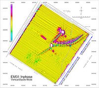
1. EM31 Conductivity Survey – Correcting GPS Offset for Uniform Line Spacing
EM31 Survey
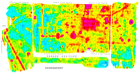
The study area covers approximately 265 × 280 m (17 acres). The EM31 survey was initially conducted from the northeast using standard data acquisition software. Uneven survey line spacing occurred due to lateral GPS antenna offset, resulting in a “train track” pattern.
On the following day, the southwestern portion of the site was surveyed using TrackMaker31. Real-time correction of the GPS antenna offset—supported by TrackMaker31 (and all versions of TrackMaker and RTmap)—resulted in a much more uniform survey line layout.
The accompanying map displays EM31 Inphase data. Click on the map to enlarge.
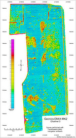
2. EM61-MK2 UXO Survey – High-Resolution Data Collection with TrackMaker
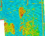
EM61-MK2 SurveyPortion of the Survey
This case study presents a UXO survey conducted with a Geonics EM61-MK2 instrument. The survey area measures approximately 300 × 150 m (1.1 acres) and was surveyed using TrackMaker31 software.
This 42-acre site (approximately 2,200 × 920 feet) was surveyed using a Geonics EM61-MK2 instrument with TrackMaker software. Survey lines were spaced at approximately 5 feet across the entire area.
The image shows EM61-MK2 Channel 3 data. A separate view of the northern portion of the site is provided to illustrate the survey layout and line spacing in greater detail. Click on any of the maps to enlarge.
3. EM31 Landfill Survey – Large Island Mapping with Real-Time QA/QC
EM31 Landfill Survey
The EM31 survey covered nearly the entire island (over 80 acres, approximately 1,100 m in the west–east direction), including landfill areas. The site contains numerous trees and dense vegetation, resulting in some irregular survey lines.
Despite challenging terrain conditions, the real-time amplitude color map enabled the operator to quickly assess data quality during acquisition.
Topographical features such as shoreline, roads, and monitoring wells are also included. This example demonstrates how RTmap can function as a standalone GPS logger. GPS data recorded using the same program and field computer—immediately after geophysical data collection—can be integrated into the final map. Click on the map to enlarge.
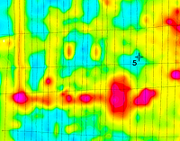
4. EM61-MK2 DGPS Survey – Fast Towed Data Acquisition and Coverage
Portion of the SurveyEM61-MK2 Survey
An example of a Geonics EM61-MK2 (Channel 3) survey with DGPS positioning is shown below. The site measures approximately 600 × 300 feet.
Real-time display of collected stations enabled efficient coverage, allowing the survey to be completed within a single day using the EM61-MK2 towed behind a quad.
A selected section of the survey area is presented separately to highlight survey line spacing and station distribution in greater detail. Click on any of the maps to enlarge.